Borneo Burning
(Image courtesy of MODIS Rapid Response Project at NASA/GSFC)
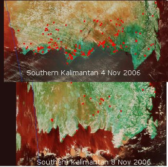
The two images above are from the Terra Modis satellite that sends back pictures of the earth every day. They show fires as red dots in the top photo taken 4 days before the bottom photo. The red discoloration of the sea in the bottom photo is silt from run-off following fires on the south coast of Kalimantan. (Map of Borneo)
Here peat fires are burning once again According to Planet Ark
a thousand orangutans have died this year due to fires in Borneo.
An average of 1 billion tonnes per year of CO2 is released into the atmosphere due to tropical peat fires in SE Asia (mostly in Indonesia) this figure dwarfs the emissions from most other sources.
In 2004, Nature News reported on the consequences of the 1997/8 fires on Borneo. In that year
fires released 13–40% as much CO2 as a typical year's global emissions from burning fossil fuels
The airport at Palangkaraya was closed for three months in 1997 - it has been closed for at least that long this year and is still closed today. The fires this year are said to be as bad as 1997 even though it has not been as dry as then. It still remains as corrupt as then.
It's worth paying a visit to Google Maps and zooming in on the south coast of Borneo . You will sea vast scars across the landscape where the rainforest has been leveled . Initally this was for Suharto's mega rice plan which was a disaster. Nowadays the land is being cleared for palm oil and rubber plantations. It is greed this year and not drought which is driving these fires which are the major contributor to the accelerated rate of increase in CO2 levels seen since 2000.
posted by Kyan gadac at 9:33 pm
![]()

0 Comments:
Post a Comment
<< Home