Looking down from above
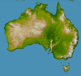
NASA has released a topographical radar image of Australia from it's Shuttle Radar Topography Mission The full size image is on this page . The image is color coded for topography and shaded from the north east. The full size jpg image file is 3.4mB in size so don't click on it and expect it to open easily in your browser! Right click and save it to your hard drive and view it a graphics program. The shading in the full size image highlights the deformations in the bedrock in places like the Flinders Ranges and the South West.
posted by Kyan gadac at 11:56 pm
![]()

0 Comments:
Post a Comment
<< Home