A jet stream powered cyclone
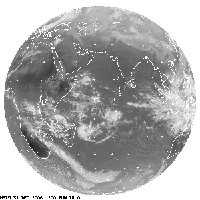
Indian Ocean Cyclone loop (203kb) (Copyright Eutmetsat 2007)
This little movie of new year's eve in the Indian Ocean - shows you what those birds were on about (give it time to load if you're on dialup). Streaming south east from Africa is a band of cloud that bridges the gap between the tropical zone and the poles. Similar bands of cloud are often seen over Australia but they don't usually connect up with the polar front quite so spectacularly.
If you look in the middle at the bottom you will see an impressive jet of clouds squirt out from the polar front in a north westerly direction. This jet goes on to provide the angular momentum which drives the creation of the cyclone forming to the south west of Western Australia.

'impossible' jet stream forecast for 3 Jan
The jet stream in the stratosphere is driving this jet of cloud, it's streaming in this quarter at close to it's maximum speed. I think we've about to see the drought break. Exactly what's going to happen is a bit of a mystery the forecast stratosphere for 48 hours time is I suspect physically impossible. As you can see it is what meteorologist might term 'extremely meridional' over the west coast. The question is going to be how it interacts with the west coast and how far north it goes. At the moment the low has stopped but the air behind it is driving up from a long way south and a secondary low seems likely. I don't know how windy it will get but it's sure gonna rain!
posted by Kyan gadac at 10:50 pm
![]()

1 Comments:
Kyan - You might like to join us in this enterprise -
http://regnans.blogspot.com/
I'd be chuffed if you did.
This is another outgrowth of barista.
Post a Comment
<< Home